
For most hikers, myself included, this section is the big attraction to the PCT. I approached it with excitement, eager to get out of the desert and ready to put my new trail legs to the test.
This would be my first time spending any significant time at elevation, and I adapted well after just a few days acclimation. The thin air, steep terrain, and sheer beauty slowed my travel, but I would hate to rush through this part. By the time I had made my first stop in Lone Pine, I was wrapped up in the mountain environment. I’d seen some information about huge burnt sections of trail in NorCal, and opted to spend longer in the Sierra, then skip large chunk of NorCal to catch back up.
The PCT crosses Forester Pass in the Sierra, the highest point on trail at 13200 ft, 4025 m. Most hikers also elect to summit Mt Whitney as a side-quest here, climbing to 14505 ft, 4421 m, the highest point in the contiguous US. As well as these features, I used my extra time to take nearly every side trail out of the Sierra, and I’m so glad I did. I saw Cottonwood Pass, Kearsarge Pass, Bishop Pass and Duck Pass, all of which are off the PCT to resupply towns. As well as taking these passes, I was able to explore a piece of the Sierra High Route from Devil’s Postpile, around the Minarets and behind Thousand Island Lake on the way into Yosemite.
This section is where I started to find myself in a new group again. Repeat trips to the town of Bishop meant that I was seeing people from all up and down the trail. Bishop became my favourite town on trail as it is so easily accessed from every pass out, and has the best resupply and accommodation options in the Sierra. In Bishop I met a larger group of people who happened to show up time and again at the Hostel California. I loved hanging out with these people, and we even went on a camping sidetrip to Mariposa Grove in Yosemite with a rented car. The time I spent in Bishop with this crew was so magnetic that I actually found it a powerful vortex. The people I met there were experts at having a good time, on and off the trail, so we ran with the name Vortexperts for the group.
Between each town stop, I would spend a week on trail, and I came to realise that each one of these weeks was a tramping trip in its own right with its own people, environment, and lesson to learn. There was a distinct beginning, middle, and end to each one. In addition to this, I was with a different group of people each time I went out. I summited Mt Whitney with Rox, a hiker known for collecting and carrying rocks along the trail. I walked from Kearsarge Pass to Bishop Pass with Rabbit and GOH, two hikers from Pennsylvania with hearts of gold. I encountered almost the entire John Muir Trail’s SOBO bubble as they all headed southwards from Yosemite, and I bashed through the bush off trail with Holiday from Louisiana, one of the most adventurous spirits I met on the entire trip.
My time in the Sierra came to an end when I headed up to Trail Days on the border of Oregon and Washington. I had spent even longer than anticipated in the Sierra, so after the festival, I headed back to NorCal, just after the point I had planned to skip to. As much as I would love to spend months and months in the Sierra, I had the rest of the trail ahead of me, and a limited time frame to fit it into.
-
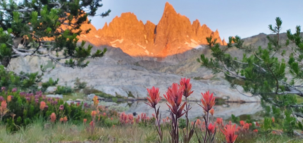
Day 59, 20 June: Entering The Sierra
I finally managed to break the Kennedy Meadows Vortex, for real this time. I stayed late at the trail magic, left around 2 pm and made it 8 miles, 12.9 km into the Sierra. Tomorrow I will climb above 10 000 ft, 3000 m, putting me in the High Sierra. I’ll stay at this elevation…
-
Day 60, 21 June: Climbing To High Sierra
Today I climbed to 10 067 ft, 3069 m, properly into the High Sierra. My distance today was 9.6 miles, 15.4 km, and I could feel the effects of elevation from about 8300 ft, 2500 m. I woke up this morning to the first cold morning I could remember in weeks. I made breakfast at…
-
Day 61, 22 June: Second Night Above 10 000 ft
Today I covered 12.8 miles, 20.7 km. The trail traversed the mountainside high above the meadows from yesterday, before dropping into a canyon to cross onto another mountain ridge. The trail quickly climbed back to 10 689 ft, 3258 m, where I made camp for the night. I got on trail at 8 am, and…
-
Day 62, 23 June: Two Months
Today marked a full two months since I started from the Southern Terminus in Campo. It’s actually kinda hard to believe it had been such a long time, and yet such a short time too. While it feels like I’ve only just got here, it also feels like a lifetime has passed as well. As…
-
Day 63, 24 June: Cottonwood Pass to Lone Pine
A couple of days ago I realized I wasn’t carrying as good food as I’d thought. Three of the meals I was carrying turned out to be only 6 g of protein, and less than 250 calories each. Rather than trying to stretch that to Kearsage Pass, I headed off trail earlier to buy more…
-
Day 64, 25 June: Back On Trail
One of the great things about Lone Pine is how easy it is to walk around. This meant I was able to get breakfast, last minute resupply, fully packed, and even a visit to the local film museum, all before noon. A shuttle driver named Kurt picked up 6 of us and took us back…
-
Day 65, 26 June: Approaching Mt Whitney
Today I covered 14.4 miles, 23.1 km from the tarn to Crabtree Meadows. The campsite at Crabtree Meadows is used as a basecamp for hikers to set up, rest and then summit Mt Whitney without having to pack, or carry all of their heavy gear with them. The day starts off very gentle. I walk…
-
Day 66, 27 June: Mt Whitney Summit
Today we left camp set up at Crabtree Meadows and pushed up to Mt Whitney summit. The trail runs 7.3 miles each way, which means today was a 14.6 mile day, 23.4 km return. The summit is at 14,505 ft, 4421 m and the air up there is thin enough to really affect energy. I…
-
Day 67, 28 June: Approaching Forester Pass
I needed a rest day today after Whitney yesterday. It was pretty slow going most of the day but I made it 8.6 miles, 13.8 km from Crabtree Meadows to Tyndall Creek. Forester Pass is 4 miles ahead and will be the highest point on the official PCT route. This morning I left from Crabtree…
-
Day 68, 29 June: Forester Pass
We went over the highest point on the PCT today; Forester Pass, at an altitude of 13 200 ft, 4025 m. The day was packed with epic views as we walked 12.3 miles, 19.8 km through the most stunning mountain landscapes on trail so far. When we left camp this morning, we were immediately climbing…

Leave a comment